Click the red flag above to locate trailhead parking
Overview & Map
The Blinnshed Loop Trail offers an excellent and easy walk through a variety of second growth forest settings. There are a few boggy areas—and waterproof footwear is recommended. The undulating topography and associated diverse wet lands, is a special feature of this walk. Especially impressive is the extensive wetland near the beginning of the trail. This trail has a junction with the Blinnshed Ridge Trail.
Category: Short walk, several streams and wet swales
Start: Trailhead, northwest corner of intersection of
Blinnshed and Opening Hill Roads
Distance: About 1.5 miles
Approximate Time: About 1-11/2 hour
Parking: Near trailhead and at The Country School
What to look for along the Blinnshed Loop
From the trailhead, follow the trail north along the well-defined woods road. On the left, at the bottom of the dip near the State Forest gate, is the junction of the Blinnshed Ridge Trail. (On that trail, almost immediately, is an old, stone-lined firepond that once provided a source of water for firefighting.)
Where the road enters a white pine plantation the Blinnshed Loop soon crosses a small, intermittent stream. This flows into the eastern end of an extensive wetland. Early spring brings lush groundcovers of skunk cabbage and false hellebore and a bit later, a yellow haze of spicebush flowers. After a short rise, the old road drops and crosses a larger stream that year-round feeds the wetland. Cross on stepstones on the north (right) side of the trail and continue up hill to a large opening where several logging roads intersect. To the left, the trail makes a short loop (described later) and returns to the intersection. The main trail turns north (right), and soon splits. This point is the base of the “loop.” Continue straight ahead (right side of loop). To the east is the bed of the stream crossed earlier. As is true of much of Cockaponsett State Forest, this area is under active forest management. The logging roads, stumps of trees, and young saplings testify to a history of harvest and regeneration cuts. The forest here is characteristic of second growth forests in our region. There is an abundant array of species, including several oaks, maples, birches and many others. Their mosaic-like pattern is determined, in part, by variations in topography and available moisture.
Just beyond where the trail passes through a stone wall, and before reaching the next one, is a small, dense plantation of Norway spruce. This group of conifers provides thermal cover for deer. In the winter, deer shelter here in this “warm” spot—one of several in this forest block.
Just beyond where the trail passes through a stone wall, and before reaching the next one, is a small, dense plantation of Norway spruce. This group of conifers provides thermal cover for deer. In the winter, deer shelter here in this “warm” spot—one of several in this forest block.
Just past the plantation, to the northwest (left) but not readily visible from the trail, are several beautiful large vernal pools that are breeding habitat for many species of frogs and salamanders.
Ascend a small rise and pass through a stone wall. The latter continues along the right side of the path and is graced by very large, tall, tulip-poplar trees. The wall marks the State Forest boundary. Soon the trail becomes less defined before it turns west (left), descends, and crosses two wet swales.
Continue west and then south along the Sate Forest boundary before descending past a large rock to an extensive and lovely wet swale. Stepstones of log sections make this crossing less formidable than it first appears. However, the next crossing of this wetland is more difficult, especially in times of high water. A decked walkway helps ford the deepest sections.
Continue south to where the trail follows, once again, old logging roads back to the base of the loop and then to the large intersection opening. Before returning to the trailhead, consider exploring the short loop to the south, mentioned earlier. This loop circles another Norway spruce “deer yard,” and affords excellent views of the extensive swamp wetland below. The wetland eventually drains to the west and into the Neck River, flowing south through the western side of this important swampland.
PLEASE NOTE: Hunting, camping, fires, cutting trees or vegetation, horses, and motorized vehicles are all prohibited on Madison Land Conservation Trust property. MLCT trails and properties are for hiking only. Dogs are allowed, but must be leashed. Please pick up all animal waste.

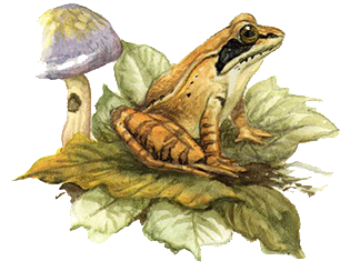
Wood Frog
If you are in the woods in the early spring and think you hear a small flock of weird ducks, it's probably mating wood frogs. They are one of the first signs of spring, and in the first warm days of March they congregate in vernal pools throughout the forested Land Trust properties. The females can lay up to 3000 eggs which take a few weeks to hatch. During the summer and spring, these handsome masked frogs move onto the forest floor and hunt invertebrates. See if you can find calling wood frogs during these warm days of March on our wonderful trails.
Painting © Michael DiGiorgio

