Take a Hike!
You’ve probably seen our small signs posted in nooks and crannies around town–perhaps even in your own backyard. The Trust obtains land through donations, bequests, and purchase. As caretakers of a wide variety of ecosystems, the Trust is often utilized as an educational resource by Madison schools, area universities and the CT Department of Energy and Environmental Protection. We may be best known for the system of blue-blazed trails that the Trust maintains throughout Madison.
Travel west on Green Hill Road from Route 79 (passing Ridge Road at 0.4 mile) to Copse Road (0.6 mile), then 0.2 mile north to the Trailhead on the right marked by a commemorative sign for CCC Camp Hadley. Park on right a few hundred feet north on Warpas Road. Trailhead 2 is 0.3 mile north on Ridge Road on left, opposite Sachem Common Road, and Trailhead 3 is just 100 feet north of Trailhead 2.
From the traffic light at the Rt. 79-Greenhill Rd. intersection, go west 1.2 miles to Warpas Rd., left on Warpas 0.2 mile to Riverside Terrace, right on Riverside Terrace to its end. Trail is at end of cul-de-sac.
Both trailheads are on Warpas Rd. From the blinking light at the Rt. 79 intersection with Horsepond Rd., go 0.2 mile north to Warpas Rd. (on left); go 1.3 miles on Warpas Rd. Trailhead 1 is on the left (east) opposite the southern boundary of the Church of Latter Day Saints church yard. Trailhead 2 is 0.2 mile south of Trailhead 1, near SNET pole #3968.
Both Trailheads, 1 and 2, are on Warpas Road. From the blinking light on Rt. 79 (the Pines), go north 0.2 mile to the first left (Warpas Rd.). Take Warpas 1.3 miles to the Church of Latter Day Saints. Trailhead 1 is just south of the Church yard in the State Forest; Trailhead 2 is 0.2 mile south of Trailhead 1. For Trailhead 3, travel west on Greenhill Rd 1.5 miles from Rt. 79 to Nortontown Rd. Turn right onto Norton-town 0.5 mile to where Opening Hill Rd. splits right. Go north on Opening Hill 0.6 mile. Trailhead #3 is on the right near SNET pole #1242.
At the end of the cul-de-sac of Jefferson Park Drive. From the blinking light at the Rt. 79/Horsepond Rd intersection, go north 0.2 mile to Warpas Road (on left). Go 0.7 miles to Jefferson Park Drive; follow to its end. The trail starts at the very end of the cul-de-sac.
From the intersection of Rt. 79, go 0.7 mile on Warpas Rd. to Jefferson Park Drive (on left). The trailhead is on the south side of Jefferson Park Drive, just as it enters its cul-de-sac.
The trailhead is on the west side of Opening Hill Rd., 3.3 miles south of where Opening Hill leaves Rt. 79 just south of the North Madison traffic circle (0.8 mile south of the Blinnshed Rd./Opening Hill Rd. intersection.)
Travel south on Opening Hill Road 2.4 miles, from where it meets Rt. 79 south of the North Madison traffic circle, to Blinnshed Road (0.6 mile south of the intersection of Overbrook Road and Opening Hill Road). Trailhead is on the right at the northwest corner of Blinnshed and Opening Hill Road intersection.
From Route 79 travel east on Green Hill Road 0.8 mile to Horsepond Road. Continue east on Green Hill another 0.8 mile to Fawn Brook Circle (on left just before bridge). Trailhead 1 is on east side of Fawn Brook, 50 feet from its junction with Green Hill Road.
On east side of Summer Hill Road, 1.4 mile south of Heatherwood and 0.3 mile north of Chestnut Hill Rd.
To reach Trailhead 2 on Georgetown Circle, go east from the traffic circle on Rt. 80, 0.7 mile to Summer Hill Road, south (right) 0.7 mile to Heatherwood. Take Heatherwood to its end, turn left onto Concord Drive; turn right onto Georgetown. Trailhead 2 is at the end of the cul-de-sac.
From the blinking light at the intersection of Rt. 79 and Horsepond Road (“The Pines”) go north on Rt. 79 0.8 mile, turn left onto Overbrook Road. Trailhead 2 is 0.3 miles on left (SNET Pole #916); Trailhead 1 is on Colonial Rd, 100 feet south from its intersection with Overbrook Road.
From the North Madison traffic circle, go east on Rt. 80, 1.3 miles to just before the bridge over the Hammonasset River. Trail-head 1 is on south side of Rt. 80, just west of the bridge.
Follow Rt 79 North to the traffic circle at Rt 80.
Take Rt 80 East from the circle toward Killingworth .8 mile and take the first right onto Summer Hill Rd. Go south on Summer Hill .3 mile and take the first left onto Shepherd's Trail. The trailhead is on the right side of the street not far from the intersection with Summer Hill Rd.
Travel west on Bradley Corners Road 1.2 miles from its junction with Opening Hill Road (0.3 mile south of where Opening Hill leaves Rt. 79), or 0.4 mile west of its junction with Race Hill Road, to St. Francis Woods Road. Trailhead 1 is 0.5 mile north on the right, opposite house #115, and Trailhead 2 is at 0.6 mile. Trailhead 3, for the short walk to the Richard C. Donnelly Memorial bench and overlook, is at the cul-de-sac 0.7 mile north of Bradley Corners Road.
From the North Madison Traffic Circle, go west on Rt. 80 1.2 miles to Race Hill Rd; north on Race Hill Rd. 0.6 mile to the trailhead on the left, (just south of the farm at the base of the hill).
From North Madison Traffic circle, go east on Rt. 80 0.7 miles to Summer Hill Rd.; north (left) on Summer Hill 0.7 mile and left on Twilight Drive for 0.5 mile to Lake Drive. Follow Lake Dr. past Bartlett Pond to the cul-de-sac and the trailhead.
Click on one of the red flags above to find a trailhead near you.
Our trails offer the public opportunities not only to experience nature in close proximity but also to visit historic sites, such as the Paper Mill on the Hammonasset River or the old Iron Works near Guilford. The Land Trust leads regularly scheduled hikes on these trails. As stewards and caretakers of Madison’s open space our job as owners of this land is to conserve it in its natural state for the benefit of the public and of the plants and animals living there.
Many members actively participate in our Stewardship Program, carefully watching over MLCT properties to ensure that they remain pristine. And because forests and tidelands know no boundaries, the MLCT recognizes the importance of regional land preservation and works with neighboring Land Trusts on everything from hikes to land purchases. For example, we collaborated with the Middlesex Land Trust to purchase the Mica Ledges, an important 100-acre area spanning the Madison-Durham border—the first such cooperative effort of its kind in the state.

TRAILS LIST
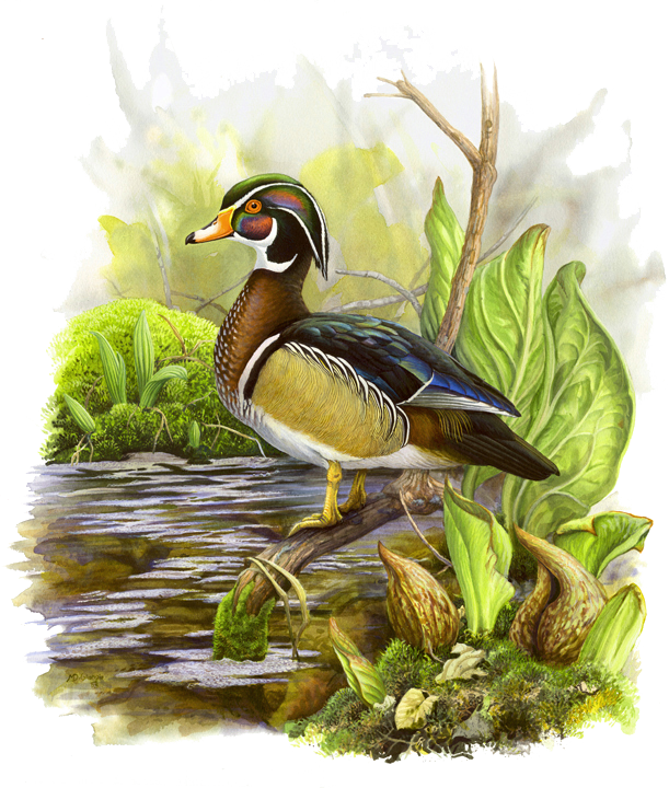
Wood Duck
Wood ducks are among the most colorful water birds we have in Connecticut. They breed in wooded swamps and shallow ponds making their nests in cavities in trees close to water. One day after hatching, the ducklings climb to the entrance of the nest and jump to the ground. The mother calls them to follow her to the water. They can swim by the time they are 1 day old. Wood ducks were in decline a century ago but have begun to rebound due to installation of nesting boxes and habitat protection. If you are lucky, you might see some wood ducks on Greist Pond at the Ironwoods Preserve.
Painting © Michael DiGiorgio